
Open, snow covered. Risk of slippery ice
Fuorns - Campra
Winter tyres are obligater for the whole winter period. Depending on the weather conditions, snow chains may be obligatory over a short period, or the pass imay close completely. See also www.lucomagno.ch
Updated on: 17.04.2024, 06:07
History
With the opening of the Disentis Monastery in 720 a.d. the Lukmanier Pass, which was easily accessible and much lower than the alpine passes, became extremely important. During the Staufer era it was considered the most important North-South axis to Italy, but soon lost this distinction to the Gotthard and Splügen passes. In 1374 the Disentis Monastery errected the «Hospezi S. Maria» and chappel at the top of the pass. Both of these objects now lie under the hydro lake. The new Hospiz as it stands today was inaugurated on 1 August 1965 and the chappel in 1967.
The Lukmanier Pass was once in contention for the construction of a trans-alpine railway as the planners were of the opinion that they would not have to build an expensive tunnel at the top. The final decision went in favour of the Gotthard. A modern road was built over the Lukmanier between 1872 and 1877. Construction of the hydro lake «Lai da Sontga Maria» meant that a new road gallery had to be built on the Bündner side. The opening of the road tunnel through the Gotthard was a blow to tourism in the area, especially as the pass was closed during the winter months from 1980 onwards.
The association «Pro Lucomagn» was founded in 2005 with the aim of keeping the pass open as long as possible during winter and was financed by the canton, regional municipalities and tourist associations in Graubünden and Ticino. The 5 year test phase had a positive outcome and the project is now financially secured for the future which is of major touristic importance to the Surselva and the Blenio Valley.
Accommodation and activities


Technical Data
Location
Signalisation
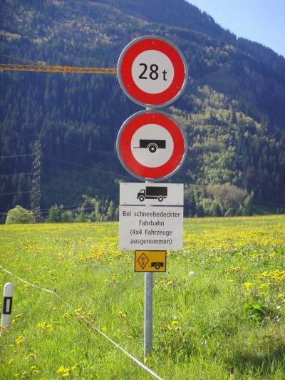
Disentis - Olivone:
- Höchstgewicht 28 t
- Bei schneebedeckter Fahrbahn Anhängerverbot für schwere Motorwagen (4x4 Fahrzeuge ausgenommen)
Passes
- -5°CClosed for the winterUpdated on: 19.04.2024, 11:04
Preda - La Punt Chamues-ch
The Tuorsbach Bridge will be closed to all traffic from 3 April 2024 to 24 May 2024 due to maintenance work. A large-scale bypass with a maximum capacity of 18 tonnes is signposted. Pedestrians and cyclists can pass the construction site on a small signposted diversions.
Bergün - Preda snow covered.
Alvaneu - Berguen no restrictions
Important note: Provided there is no major snowfall, the pass is scheduled to open on Friday, 17 May 2024.
Next assessment: Friday 3 May 2024 - -5°COpen, snow covered. Risk of slippery iceUpdated on: 23.04.2024, 07:50
Pontresina - San Carlo
Winter tyres are obligatory for the whole winter period. Depending on the weather conditions, snow chains may be obligatory over a short period, or the pass may close.
- 1°COpen, no restrictionsUpdated on: 22.04.2024, 10:18
Lungern - Brienzwiler
Note: Due to maintenance work, a section between the turn-off to Meiringen (just below the top of the pass) and Brienzwiler will be closed between 15 April 2024 and 3 May 2024. The diversions via Meiringen is signposted.
Winter tyres are obligatory for the whole winter period. Depending on the weather conditions, snow chains may be obligatory over a short period, or the pass may close completely.
- -5°CClosed for the winterUpdated on: 10.04.2024, 18:30
Tschuggen- Susch
Davos - Tschuggen no restrictions
Vehicle transport Flüela/Vereina Tel. 0041 81 288 37 37
- -7°CClosed for the winterUpdated on: 09.04.2024, 17:47
Realp - Oberwald
If weather conditions permit, the following opening dates are planned: Partial opening up to Tiefenbach on 8 May 2024 and the opening of the pass on 29 May 2024.
- -4°CClosed for the winterUpdated on: 19.04.2024, 11:06
La Motta - Country border
Important note: Provided there is no major fresh snowfall, the pass is scheduled to open on Monday, 3 June 2024, subject to change.
Next assessment: Friday 3 May 2024Traffic information for the bordering South Tyrol/Passes: www.suedtirol.com/verkehr/berg-paesse
- -3°CClosed for the winterUpdated on: 10.11.2023, 16:26
Sarnen - Entlebuch
On the Obwaldnerside open to Langis.
- -2°CClosed for the winterUpdated on: 10.11.2023, 09:59
Giswil - Sörenberg, "Panoramastrasse"
Important note: On 9.11.2023 the Panorama Road will closed to traffic at 1600 hrs. Winter closure.The road will stay open on the Obwaldner side up to Mörlialp.
Restrictions for coaches and trucks see section Signalization.
- -5°CClosed for the winterUpdated on: 09.04.2024, 17:51
Hospental - Airolo
Weather conditions permitting, the Gotthard Pass will be open to traffic again in mid-May 2024.
Tremola (Strada turistica) Passhöhe - Airolo: 3.5 t. Winter closure - -5°CClosed for the winterUpdated on: 22.04.2024, 06:08
Guttannen - Gletsch
On the Bern side, the road is open today, 22.4.2024 from 0600 hrs to Handegg.
Important note: The Guttannen - KW Handeck section is only permitted for snow sports enthusiasts. Tickets for the Handegg - Gerstenegg LSB must be purchased online at www.grimselwelt.ch by 4.00 pm the evening before. Current avalanche and road bulletin at https://www.grimselstrom.ch/media/info/Lawinenbulletin.pdf
- -4°CClosed for the winterUpdated on: 16.10.2023, 11:05
Bourg-St-Pierre - national border
Important note: On 16.10.2023 the Great Saint Bernard Pass will be closed at 1100 hrs. Winter closure.
- -4°CClosed for the winterUpdated on: 23.10.2023, 09:42
Meiringen - Grindelwald
The reopening is scheduled for May 18, 2024 (Pentecost).
There is a general driving ban on motorized traffic between Schwarzwaldalp and Grindelwald (Hotel Wetterhorn).
-
- -4°COpen, no restrictionsUpdated on: 23.04.2024, 11:56
Bivio - Silvaplana
Winter tyres are obligatory for the hole winter period. Depending on the weather conditions, snow chains may be obligatory over a short period, or the pass may close
- -6°CClosed for the winterUpdated on: 09.04.2024, 17:43
Urigen - Urnerboden
Weather conditions permitting, the Klausen Pass is scheduled to open on 17 May 2024.
Info for coach transport – summer 2024
2.30 m wide, double axis and 18 t vehicles do not need permission to use the road, also on weekends.
From the opening of the pass in 2024: single level, 2.55 m wide, double axis and max. 18 t heavy coaches may use the Klausen pass road from Monday to Friday but must have special permission. Monday, Wednesday and Friday from Unterschächen to Linthal. Tuesday and Thursday from Linthal to Unterschächen. Permission is granted by the Strassenverkehrsamt Kanton Uri, or Kanton Glarus.Permits for Linthal – Unterschächen can be obtained at:
Strassenverkehrs- u. Schifffahrtsamt des Kanton Glarus,
Mühleareal17
8762 Schwanden
Tel 055 646 54 00
E-Mail: stva@gl.ch
Permits for Unterschächen - Linthal can be obtained at:
Amt für Strassen- und Schiffsverkehr
Gotthardstrasse 77a
6460 Altdorf
Tel 041 875 28 02
E-Mail: sonderbewilligungen@ur.ch
https://www.ur.ch/publikationen/6500 - -3°COpen, snow covered. Risk of slippery iceUpdated on: 17.04.2024, 06:07
Fuorns - Campra
Winter tyres are obligater for the whole winter period. Depending on the weather conditions, snow chains may be obligatory over a short period, or the pass imay close completely. See also www.lucomagno.ch
- -1°COpen, no restrictionsUpdated on: 10.04.2024, 14:58
Silvaplana - Casaccia
Winter tyres are obligatory for the hole winter period. Depending on the weather conditions, snow chains may be obligatory over a short period, or the pass may close Complete,
- -8°CClosed for the winterUpdated on: 30.10.2023, 14:15
All' Acqua - Ulrichen
The road will stay open on the Ticino side up to All’Acqua
- -4°CClosed for the winterUpdated on: 16.04.2024, 11:46
Tschamut - Andermatt
Disentis- Tschamut no restrictions
Important note: Provided there is no major snowfall, the pass is scheduled to open on Friday, 26 April 2024
Next assessment: None
- -1°COpen, no restrictionsUpdated on: 23.04.2024, 11:11
Zernez - Tschierv
Winter tyres are obligatory for the whole winter period. Depending on the weather conditions, snow chains may be obligatory over a short period, or the pass may close completely.
Traffic information for the bordering South Tyrol/Passes: www.suedtirol.com/verkehr/berg-paesse
- -3°CClosed for the winterUpdated on: 07.03.2024, 17:35
Muotathal - Glarus
Glarus side:
Schwyzer side:
Winter closure between Fruttli and Gampel.
On the Schwyz side of the Pragel Pass, the renovation work between Stalden and Fruttli will continue from March 20 until June 7, 2024. This stretch will be closed to all traffic between Monday and Friday from 07:00 to 1800 hours.
Note: The following traffic restrictions generally apply to the Pragelpass road:
- On Saturdays and Sundays, motorised vehicles and motorbikes are prohibited 5.5 km after the top of the pass (cantonal border SZ/GL to Richisau, approx. 2 km)
- Maximum weight 3.5 tonnes (SSV signal 2.16) except for agricultural, alpine and forestry traffic, traffic for the construction, operation and maintenance of public and private works (incl. electrical infrastructure), traffic for milk-processing plants and military traffic;
- Driving ban for trailers (SSV signal 2.09) except for agricultural, alpine and forestry traffic, traffic for the construction, operation and maintenance of public and private works (incl. electrical infrastructure), traffic for milk processing plants and military traffic;
- Maximum weight for agricultural, alpine and forestry traffic, traffic for the construction, operation and maintenance of public and private works (incl. electrical infrastructure) and traffic for milk processing plants incl. trailers 32 tonnes (SSV signal 2.16);
- Maximum weight of military traffic including trailers 12 tonnes.
- On public holidays that do not fall on a Saturday or Sunday, the Pragel Pass is normally passable.See also: https://www.bezirk-schwyz.ch/aktuell/pragelpass/
- -1°CClosed for the winterUpdated on: 19.04.2024, 11:05
Hinterrhein - San Bernardino (Pass road, italien road).
Important note: Provided there is no major snowfall, the pass is scheduled to open on Friday 17 May 2024, subject to change. Next assessment: Friday 3 May 2024
- -6°COpen, no restrictionsUpdated on: 23.04.2024, 08:17
Brig - Gondo
Winter tyres are obligatory for the whole winter period. Depending on ithe weather conditions, snow chains may be obligatory over a short period, or the pass may close completely.
- -1°CClosed for the winterUpdated on: 08.04.2024, 17:18
Splügen - Country border
Important note: Provided there is no major fresh snowfall, the pass is scheduled to open on Thursday, 2 May 2024, subject to change.
Next assessment: Monday, 22 April 2024
- -6°CClosed for the winterUpdated on: 19.04.2024, 15:51
Wassen - Innertkirchen
On the Bern side, the road is open today, 15.4.2024 from 1500 hrs to Obermad.
Note: Gental open to Haberen.
On the Uri side, the road is open as far as Färnigen.
Weather conditions permitting, the Susten Pass will be open again on 14 June 2024. The partial opening on the Uri side up to Sustenbrüggli is expected to be possible again on 29 May 2024.
- -4°CClosed for the winterUpdated on: 19.04.2024, 11:11
Sta. Maria i. M. - country border
Expected passport opening towards the end of May at the beginning of June.
Next assessment: End of week 17Traffic information for neighbouring South Tirol pass: www.suedtirol.com/verkehr/berg-paesse