
Open, no restrictions
Bivio - Silvaplana
Winter equipment is mandatory during the winter months. Snow chains are compulsory for a limited period of time depending on the circumstances, as is any closure of the pas
Unchanged valid since:: 10.06.2026, 21:54
History
The remains of Roman columns and coins found on the top of the pass point to an early use of this alpine traverse even with two wheeled barrows. The steeper and more avalance endangered Septimer Pass to the west would have been direct competition at the time.
Once the trading routes were established, the importance of the Julier Pass diminished, becoming even less important when the road was built over the Septimer Pass in 1387.
The Julier Pass was mainly used for access to the Upper Engadin and to the Bernina Pass and a road was constructed over the pass between 1820 and 1826. At this time the Julier became more important than the Septimer Pass on one hand because of the more difficult terrain on the Septimer and on the other had because the Engadin was economically more important for the canton. This was the first road-building project financed by the canton.
During the second half of the 19th century a number of changes were made to the route because of the increased number of vehicles travelling to the health resorts in the Upper Engadin. The opening of the Albula line by the Rhätischen Railway in 1903 meant that, once again, far less traffic used the road. In 1923, when the Swiss Federeal Government put pressure on the canton to build a pass road suitable for motorised vehicles, the canton of Graubunden chose the Julier Pass and the pass road was built between 1935 and 1940 the first alpine traverse with asphalt. Today, the Julier Pass is the most important northern access to the Engadin and is open all year round.
Accommodation and activities

Technical Data
Location
Signalisation
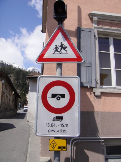
Tiefencastel - Silvaplana:
- Anhänger an schweren Motorwagen vom 15.4. - 15.11. gestattet
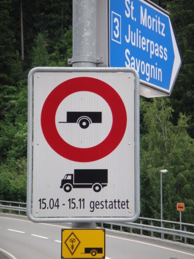
Tiefencastel - Silvaplana:
- Anhänger an schweren Motorwagen vom 15.4. - 15.11. gestattet
Passes
- Open, with restrictionsUnchanged valid since:: 03.08.2026, 07:5819°C12%30.4 KmWinter closure (Oct/May)
Preda - La Punt Chamues-ch
The Albulastrasse, between Crap Alv and Albula Hospiz, must be closed to all traffic on the following days, from 8:00 a.m. to 5:00 p.m., due to road resurfacing work.
Tuesday, August 25, 2026; Wednesday, August 26, 2026; Thursday, August 27, 2026
The closures are subject to weather conditions. The alternate dates are: Tuesday, September 1, 2026; Wednesday, September 2, 2026; Thursday, September 3, 2026 - Open, no restrictionsUnchanged valid since:: 13.07.2026, 08:4318°C10%37 Kmopen all year round
Pontresina - San Carlo
Winter tyres are obligatory for the whole winter period. Depending on the weather conditions, snow chains may be obligatory over a short period, or the pass may close. - Open, no restrictionsUnchanged valid since:: 29.03.2026, 17:5626°C13%13 Kmopen all year round
Lungern - Brienzwiler
Winter tyres are obligatory for the whole winter period. Depending on the weather conditions, snow chains may be obligatory over a short period, or the pass may close completely.
- Open, with restrictionsUnchanged valid since:: 14.07.2026, 08:2219°C14.6%27 KmWinter closure (Jan /May)
Tschuggen - Susch
Note: Nighttime closure between the pass summit and Susch due to construction work. No detour.
Monday, August 17, 2026, through Saturday, August 22, 2026, and Monday, August 24, 2026, through Saturday, August 29, 2026,
closed to all traffic between 10:00 p.m. and 5:00 a.m. each day.Vehicle transport Flüela/Vereina Tel. 0041 81 288 37 37
- Open, no restrictionsUnchanged valid since:: 03.08.2026, 11:2018°C11%29 KmWinter closure (Oct/May)
- Open, no restrictionsUnchanged valid since:: 10.06.2026, 17:5819°C12.7%21.3 KmWinter closure (Oct/May)
La Motta - Country border
Traffic information for the bordering South Tyrol/Passes: www.suedtirol.com/verkehr/berg-paesse
- Open, no restrictionsUnchanged valid since:: 29.05.2026, 17:0626°C11%32 KmWinter closure from Langis: November - April
Sarnen - Entlebuch
The urgent structural work has been completed. The road is now open again.
On the Obwalden side, the road remains open during the winter as far as Langis.
- Open, no restrictionsUnchanged valid since:: 13.05.2026, 14:4227°C12%39 KmWinter closure from Mörlialp (Oct / May)
Giswil - Sörenberg, "Panoramastrasse"
Important notice: On 13 May 2026, Panoramastrasse will reopen to traffic from 3 pm.
Important note: During the winter, the road on the Obwalden side will remain open as far as Mörlialp.
Important note: Restrictions for coaches and trucks see section Signalization.
- Open, no restrictionsUnchanged valid since:: 21.05.2026, 19:1521°C9%24 KmWinter closure (Oct/May)
Hospental - Airolo
Tremola (Strada turistica) Passhöhe - Airolo: 3.5 t. The Tremola will reopen on Friday 22 May 2026 from 08:00
- Open, no restrictionsUnchanged valid since:: 01.08.2026, 13:5323°C11%24 KmWinter closure (Oct/May)
Guttannen - Gletsch
- Open, no restrictionsUnchanged valid since:: 22.06.2026, 17:4919°C11%44 KmWinter closure (Oct/May)
Bourg-St-Pierre - national border
Important notice: The Great St Bernard Pass will reopen on 22 June 2026 from 1100 hours.
- Open, no restrictionsUnchanged valid since:: 15.05.2026, 06:3124°C15%28 KmWinter closure (Oct/May)
Meiringen - Grindelwald
Pass opening 2026: Ascension Day, 14 May 2026, with the start of bus services.
There is a general driving ban on motorized traffic between Schwarzwaldalp and Grindelwald (Hotel Wetterhorn).
- Open, no restrictionsUnchanged valid since:: 02.04.2026, 13:5428°C10.1%17 Kmopen all year round
Schwyz - Oberiberg
- Open, no restrictionsUnchanged valid since:: 10.06.2026, 21:5419°C12%16 Kmopen all year round
Bivio - Silvaplana
Winter equipment is mandatory during the winter months. Snow chains are compulsory for a limited period of time depending on the circumstances, as is any closure of the pas
- Open, no restrictionsUnchanged valid since:: 22.07.2026, 17:4724°C9%35 KmWinter closure (Oct/May)
Urigen - Urnerboden
Block lifted
Notice regarding roadworks: To ensure the safety of the road infrastructure, a retaining wall on the valley side is being renovated in the Schlierenegg area (located between the pass summit and Urnerboden). The works are expected to last until October 2026. Traffic in the construction zone is being controlled by traffic lights. There may be short delays.
Info for car travel summer 2026:
2.30 m wide, two-axle and 18-ton vehicles do not require a permit, also applies at weekends. Timing must be coordinated with Postbus routes.
From the opening of the pass in 2026 until its closure in 2026, single-decker, 2.55 m wide, two-axle and max. 18-ton touring cars (trailer ban) may travel on the Klausen Pass from Monday to Friday with a special permit. Monday, Wednesday and Friday from Unterschächen to Linthal. Tuesday and Thursday from Linthal to Unterschächen. Timing must be coordinated with Postbus routes.
Permits can be obtained from the Road Traffic Office of the Canton of Uri or the Canton of Glarus.Permits for Linthal – Unterschächen can be obtained at:
Strassenverkehrs- u. Schifffahrtsamt des Kanton Glarus,
Mühleareal17
8762 Schwanden
Tel 055 646 54 00
E-Mail: stva@gl.ch
Permits for Unterschächen - Linthal can be obtained at:
Amt für Strassen- und Schiffsverkehr
Gotthardstrasse 77a
6460 Altdorf
Tel 041 875 28 06
E-Mail: sonderbewilligungen@ur.ch
https://www.ur.ch/publikationen/6500 - Open, no restrictionsUnchanged valid since:: 30.07.2026, 12:0722°C9%39 Kmopen all year round
Fuorns - Campra
Winter tyres are obligater for the whole winter period. Depending on the weather conditions, snow chains may be obligatory over a short period, or the pass imay close completely. See also www.lucomagno.ch
- Open, no restrictionsUnchanged valid since:: 16.07.2026, 14:4325°C9%30 Kmopen all year round
Silvaplana - Casaccia
Winter tyres are obligatory for the whole winter period. Depending on the weather conditions, snow chains may be obligatory over a short period, or the pass may close Complete,
- Open, no restrictionsUnchanged valid since:: 05.06.2026, 06:5821°C13%38 KmWinter closure (Oct/May)
All' Acqua - Ulrich
On the Ticino side open during the winter to All'Acqua.
- Open, no restrictionsUnchanged valid since:: 26.06.2026, 21:1722°C6%23 KmWinter closure (Oct/May)
Tschamut - Andermatt
- Open, no restrictionsUnchanged valid since:: 08.07.2026, 20:5219°C14.3%35 Kmopen all year round
Zernez - Tschierv
Winter tyres are obligatory for the whole winter period. Depending on the weather conditions, snow chains may be obligatory over a short period, or the pass may close completely.
Traffic information for the bordering South Tyrol/Passes: www.suedtirol.com/verkehr/berg-paesse
- Open, no restrictionsUnchanged valid since:: 02.07.2026, 15:0926°C18%50 KmWinter closure (Oct/May)
Muotathal - Glarus
The following traffic restrictions apply to the entire Pragelpass road:
1. Motor vehicles and motorcycles are prohibited on Saturdays and Sundays, 5.5 km after the
pass summit (cantonal border SZ/GL to Richisau, approx. 2 km)
2. On public holidays that do not fall on a Saturday or Sunday, the Pragelpass is normally passable
(except winter closure)
3. Maximum weight 3.5 tons (SSV signal 2.16) except for agricultural, alpine and forestry
traffic, traffic for the construction, operation and maintenance of public and private works (incl.
electrical infrastructures), traffic for milk processing plants and military traffic;
4. Driving ban for trailers (SSV signal 2.09) except for agricultural, alpine and forestry
traffic, traffic for the construction, operation and maintenance of public and private works (incl.
electrical infrastructures), traffic for milk processing plants and military traffic;
5. Maximum weight of agricultural, alpine and forestry traffic, traffic for the construction, operation and maintenance
of public and private works (incl. electrical infrastructure) and traffic for
milk processing plants incl. trailers 32 tons (SSV signal 2.16);
6. Maximum weight of military traffic incl. trailers 12 tons.
For special permits relating to weight restrictions, please use the application form on the
online portal. https://www.bezirk-schwyz.ch/aktuelles/pragelpass/ - Open, no restrictionsUnchanged valid since:: 17.05.2026, 12:1922°C9.7%17 KmWinter closure (Oct/May)
Hinterrhein - San Bernardino (Pass road, italien road).
- Open, no restrictionsUnchanged valid since:: 06.05.2026, 16:2722°C9%67 Kmopen all year round
Brig - Gondo
Winter tyres are obligatory for the whole winter period. Depending on ithe weather conditions, snow chains may be obligatory over a short period, or the pass may close completely.
- Open, with restrictionsUnchanged valid since:: 31.07.2026, 09:5417°C13%39 KmWinter closure (Oct/May)
Splügen - Country border
Splügenstrasse will be closed due to roadworks (Galerie Bofffalora IT) between Zoll Berghaus and the national border from 3 to 7 August (Correction: The Splügen Pass will be open to traffic as usual on Aug. 8!) and 24 to 28 August 2026, between 8.30 am and 11.30 am and 2.00 pm and 5.30 pm on each of these dates.
- Open, no restrictionsUnchanged valid since:: 01.08.2026, 13:5422°C9%46 KmWinter closure (Oct/May)
Wassen - Innertkirchen
- Open, no restrictionsUnchanged valid since:: 08.07.2026, 21:0017°C12%33 KmWinter closure (Oct/May)
Sta. Maria i. M. - country border
Important notice: Due to a sporting event, the road between Bormio and Passo dello Stelvio (Stilfserjoch) will be closed on Sunday 12 July 2026 between 0800 and 1400.
The Umbrail Pass is open to traffic as normal up to the summit/national border.Traffic information for neighbouring South Tirol pass: www.suedtirol.com/verkehr/berg-paesse